Would you like to discover one of Andalucia’s most fascinating hiking trails?
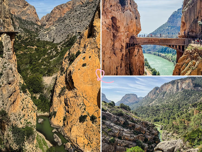
The Caminito del Rey, located in the province of Malaga, is a spectacular hike offering breathtaking views of rocky gorges and verdant valleys.
Cut into the side of a cliff for the construction of a dam at the beginning of the 20th century, this path has now been rehabilitated as a sports trail.
In this article, you’ll find our photos and tips for making the most of the Caminito del Rey hike in Malaga.

This opinion is completely independent, based on our experiences. We made our own choices, visited the area anonymously, and paid our bills in full.
Tour summary and map
- Distance: 7.7km (linear route in one direction only)
- Duration: between 2h30 and 3h
- Difficulty: easy to moderate
- Difference in altitude: negative difference in altitude of around 100 metres
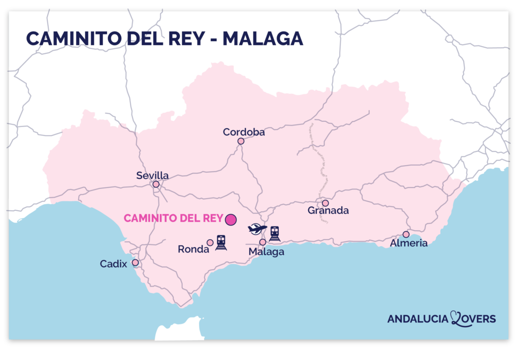
Here’s the map of the hike:

Is the Caminito del Rey hike worth it? Our review
Absolutely! We even consider it a must-see in Malaga!
Once considered one of the most dangerous in the world, the course is now completely safe and still promises a dose of adrenalin despite the improvements.

Our favorite moment
We loved the whole course, which promises an immersion in a sublime natural setting, with its volutes of stone, turquoise water and verdant vegetation. But perhaps our favourite moment was the ultimate challenge, crossing the suspension bridge 100m above sea level between the narrow gorges!

Opt for a guided tour of the Caminito del Rey: see more info, prices and availability.
We loved being carried along, discovering many anecdotes about the flora and fauna and the construction of the dam.
PLAN YOUR DREAM TRIP TO andalucia
All the information you need for your trip:
- 7 maps that make planning easier
- + 150 pre-selected locations
- Practical advice
- 300+ photos to help you choose

What are the difficulties?
Here are the main difficulties you may encounter on the trail:
Understanding the sensation of vertigo
For those afraid of heights: avoid this hike! Most of the route is on a cliff face. Rest assured, everything is absolutely secure: all walkways are reinforced, and solid iron grids form the railings. Finally, the only thrill you’ll get is when you cross the 600-metre suspension bridge at the end of the route.

The crowds
The Caminito del Rey trail suffers from overcrowding (up to 1,400 people a day)! We therefore advise you to visit during the week and out of season to avoid overcrowding the route.
Finally, please note that the entire course has been concreted over, which takes away some of its wild charm…

The stairs
The ground is mainly flat with small gravels, sometimes irregular, but we especially noted the presence of several staircases on the course (concrete, wooden and some a little embossed). This hike is therefore not suitable for those with bad knees.

Sun exposure
Finally, note that if the vegetation is dense, you’ll find very few areas of shade along the route: so opt for early-morning visits in summer, when the heat is extreme, and bring water and head protection.
In winter, on the other hand, the cold can be bitterly cold at altitude, so bring warm clothes and a windbreaker.
Finally, note that there are very few places to sit on the path.

WHERE TO STAY IN Málaga
Our favorites: neighborhoods and hotels
In the historical center
Hotel Palacio Solecio – see photos and availability
Near the sea, Playa de la Magualeta
Gran Hotel Miramar – see photos and availability
In the Soho district
Hotel Only You Malaga – view photos and availability

Access
Where Caminito del Rey is – map
- Located in the province of Malaga between the towns of Álora, Antequera and Ardales.
- From Malaga = 1h30 drive
- Here is a map to help you find your way:

Access road and parking lot
Driving from Malaga to the Caminito del Rey site couldn’t be easier!
You’ll take the freeway before accessing small country paths.
For our part, we loved watching the lush green valleys unfold along the way.

There are several options for parking:
- If you prefer to have your vehicle directly accessible after the hike: Parking P2 (El Chorro).
- If you prefer to be close to the entrance: Parking P1 (Ardales). However, be prepared to take the shuttle back to the starting point.
- If you want a centralized option that’s easy to organize online: Parking at the Visitor Center(P). It’s a flexible alternative.
As a general rule, we advise you to arrive at your chosen parking lot at least one hour before the start of your visit to avoid any logistical stress. The few free places along the road are taken by storm.
RENT A CAR IN Andalucia
- Compare prices on our preferred platform: DiscoverCars – one of the best rated sites.
- Choose a compact car, as some villages have very narrow streets!
- Think ofcomprehensive insurance for the same reason
- Book early for choice.

Access by public transport or organized transfer
We highly recommend the option of an organized tour for this hike!
Ticket includes:
- Bus transfer from Malaga
- Priority access to the site
- Guided tour (available in several languages)
We found the organization very smooth (punctual departure, comfortable bus equipped with charger sockets) and we also appreciated that they offered a small bottle of water at the start of the route. Book your Caminito del Rey excursion now!
It’s also worth noting that an excursion avoids the hassle of individual organization, such as booking tickets in advance (which can be tedious), renting a car or reserving parking. What’s more, opting for a tour eliminates the need for a separate shuttle, as the tour bus will pick you up and drop you off at the departure point, simplifying the logistics of your visit.

Finally, we don’t recommend taking the train to get to Caminito del Rey, as this is a restrictive alternative. There are very few trains from Málaga to El Chorro station, and once at the station, you’ll need to take a shuttle bus (15min) to the parking lot at the start of the hike. Not to mention the fact that you’ll need to be sure that the same shuttle will fit in with your train journey back from the hike…
Where is the trailhead?
Once you’ve parked, we recommend you take the tunnel next to the El Kiosko restaurant. This short tunnel (1,500m) leads to a 1.5km path that takes you to the Visitor Center, where you are given helmets (mandatory) and safety instructions.

Useful tips
How long
Once you’ve reached the official start of the hike, you should allow 2h30 to 3h for a leisurely stroll. The route is 7.7km in one direction and does not form a loop. Allow 30min extra for shuttle time to and from the site.
Best moment
We advise you to plan your discovery of the trail in spring to take advantage of the full bloom! Avoid the hot summer months.
Finally, as the Caminito del Rey trail suffers from overcrowding, we advise you to visit during the week and early in the morning to avoid the crowds.

The meaning of hiking
The route is one-way (impossible to make a loop or retrace your steps).
If you’re on your own, you can let yourself be guided by the many signs along the way.
But be warned: you’ll have a lot to do:
- entry and exit paths,
- suspended walkways that cross sections of the canyon,
- a stretch of road at the end of the route.

Hiking with children
The activity is forbidden to children under 8.
If your children are old enough, they’re sure to enjoy the adventure! Just be sure to frame them well on narrower passages.

Installations
Toilets are available at the entrance and exit of the hiking trail.
Be sure to take precautions, as there will be nothing on the trail, and as it’s very busy, you won’t be able to relieve yourself away from the world.
At the end of the course, a snack area offers a variety of snacks.
There are plenty of signs along the way to help you find your way around the space, and the loan of a helmet is included in the price of the ticket.

Cross the 3 spectacular gorges of Caminito del Rey
Gaitanejo Gorge marks the beginning of your adventure. Accessible from a footbridge, this impressive 10-meter-wide canyon offers a first glimpse of the natural wonders that await you. We particularly enjoyed the shades of color on the rock faces, blending in with the sparse vegetation.

As you pass the Tajo de las Palomas, the second canyon, and cross the Puente del Rey, you’ll be enchanted by the radical change of scenery that leads to the Valle del Hoyo. A veritable haven of greenery, this valley is bordered by a dense pine forest.
Although considered an invasive species, pines play an essential role in the local ecosystem. Their powerful roots stabilize the soil and reinforce the banks of the channel dug through the valley, preventing erosion. It was in this lush natural setting that we made a contemplative stop during our visit!

Next, you’ll reach the spectacular Gorge des Gaitanes. Here you’ll find the Mirador de Cristal, a glass platform offering a breathtaking view of the landscape below. It’s the ideal place to admire the San Cristobal alcove, an impressive rock formation that seems to defy time.
Keep in mind that access to the balcony is limited to 4 people at a time!

And finally, the moment we’ve all been waiting for: the crossing of the suspension bridge, the highlight of the show!
We were almost disappointed that it didn’t last longer, as the crossing is only 600 metres long! Once you’ve crossed the bridge, you’ll have an even clearer view of the rock and reservoirs of El Chorro. This unique panorama, combining the immensity of natural landscapes and the majesty of human infrastructures, marks a grandiose conclusion to this unforgettable adventure.

Diving into the heart of Andalucia’s wilderness
The first thing that struck us when we arrived on the trail was the beauty and variety of the landscape! In fact, you’ll alternate between densely wooded areas, fascinating rocky zones and pretty flowery spots. And let’s not forget the turquoise-green Guadalhorce River that winds its way through the course!

With almost 2,000 species on the site, there are just as many different habitats for a rich and diverse fauna. As the hike is designated as a special protection area for birds, we were lucky enough to spot griffon vultures soaring overhead. Some can reach 2m with their wings spread!
If you’re lucky, you may spot other species such as foxes, warthogs or ibex, adding an epic touch to your walk.

Finally, take time to observe the amazing rock formations! Right from the start of the route, in the Gaitanejo Gorge, these natural shapes are particularly spectacular. Here you’ll discover a series of small cavities, gullies and basins hanging from the walls or carved into the bottom of the gorge, the result of water erosion and the dissolution of limestone in the rock.

Discover the history behind breathtaking landscapes
The Caminito del Rey (Little Path of the King) takes its name from King Alfonso XIII, who came not to hike, but to inaugurate the Conde del Guadalhorce dam in 1921.
Built between 1901 and 1905 to give workers access to the hydroelectric sites in the steep El Chorro gorge, this cliff-side suspension path was originally intended for industrial use.
Over time, it became notoriously dangerous, attracting many adventurous (or unaware!) hikers.
After a period of neglect, the trail was fully rehabilitated and reopened to the public in March 2015, now allowing visitors to discover this unique heritage in complete safety.

Did you know? Gorge des Gaitanes was once under the sea! Hence the ammonite fossil visible on one of the walls before the suspension bridge. Protected by a sheet of methacrylate, this fossil is the remnant of a Jurassic beach dating back thousands of years, still preserving the undulations of the sandy bottom, frozen in the rock. The term ammonite, inspired by the Egyptian god Amon, refers to its spiral shape resembling a ram’s horn.

Is the Caminito del Rey dangerous?
Before its renovation in 2015, the Caminito del Rey was known as one of the most dangerous trails in the world. Today, we can assure you that the route is perfectly safe, with strict rules to ensure the safety of hikers.
Helmets are compulsory and provided on site.
Please note, however, that the trail may be closed in the event of adverse weather conditions (rain, wind) to avoid any risk.
Find out more on the official website here.

Can you hike the Caminito del Rey on your own?
It’s entirely possible to visit the site on your own, but we strongly advise you to hire qualified local guides. Not only will they provide you with a wealth of anecdotes about the Caminito del Rey, but they’ll also simplify your experience: no need to worry about booking tickets or parking in advance, and you’ll enjoy no-wait access to the site’s entrance.
Book your Caminito del Rey excursion now!
Subscribe to our Newsletter
- Get away from it all with Region Lovers’ beautiful destinations!
- Once a month
- Advertising-free
PLAN YOUR TRIP TO Andalusia
Inspiration
- Best things to do in Andalucia
- The most beautiful cities
- The most beautiful white villages
- Cathedrals
- Archaeological sites
- Seville, Cordoba or Granada? (coming soon)

Practice
- Where to stay in Andalucia (coming soon)
- Best luxury hotels in Andalusia (coming soon)
- Rent a car in Andalusia (coming soon)
- Itineraries: 3 days – 4 or 5 days – 1 week – 10 days – 2 weeks (coming soon)

Places not to be missed
- Things to do in Sevilla
- Things to do in Cordoba (coming soon)
- Things to do in Granada
- Things to do in Ronda
- Things to do in Malaga
- Things to do in Cadiz (coming soon)


